
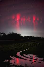
Most people associate lightning with bright flashes that streak downward from clouds to the ground. However, some of the most fascinating electrical events in Earth’s atmosphere occur far above the storms themselves, often hidden from view. One of the most remarkable examples is a phenomenon known as a red sprite—a rare and beautiful burst of light that appears high above powerful thunderstorms.
A striking example of a red sprite was photographed above the plains of Oklahoma, where a strong thunderstorm produced conditions suitable for this unusual atmospheric event. Although these flashes last only a fraction of a second, they offer scientists valuable insights into the complex electrical processes taking place in Earth’s atmosphere.
What Is a Red Sprite?
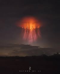
A red sprite is a type of large-scale electrical discharge that forms high above active thunderstorms. Unlike conventional lightning, which typically travels between clouds or from clouds to the ground, sprites occur in the upper atmosphere, often reaching altitudes of nearly 60 miles (100 kilometers).
Sprites usually appear as glowing red or reddish-orange structures with branching tendrils that can resemble jellyfish, carrots, or columns of light. Because they occur so high above storms and last only a few milliseconds, they are difficult to observe without specialized equipment or favorable viewing conditions.
Scientists classify sprites as part of a broader group of atmospheric events known as Transient Luminous Events (TLEs), which also include phenomena such as blue jets and elves. These events help researchers better understand the interaction between thunderstorms and the upper layers of the atmosphere.
Why Do Red Sprites Occur?
Red sprites are typically triggered by especially powerful positive cloud-to-ground lightning strikes. When a strong lightning discharge occurs, it can temporarily alter the electrical balance in the atmosphere above the storm. This disturbance can create an electrical breakdown in the thin air of the mesosphere, producing the glowing red structures observed from the ground and from aircraft.
Because the atmosphere becomes less dense at higher altitudes, the electrical discharge behaves differently than ordinary lightning. Instead of producing the bright white or blue flashes commonly seen during storms, sprites emit a reddish glow due to the interaction of electrical energy with nitrogen molecules in the upper atmosphere.
A Phenomenon Once Considered Unbelievable
For decades, pilots reported seeing unusual red flashes above thunderstorms during nighttime flights. These observations were often met with skepticism because there was little photographic evidence to support the claims.
That changed in 1989 when researchers accidentally captured the first documented image of a red sprite while testing low-light television equipment. The discovery confirmed that the reports from pilots were accurate and sparked a new field of atmospheric research.
Since then, advances in photography and video technology have allowed scientists and weather enthusiasts to capture thousands of images of sprites around the world. Even so, they remain relatively uncommon and are still considered one of the most intriguing weather-related phenomena visible from Earth.
Why Oklahoma Is a Good Place to Observe Them
The central United States, including Oklahoma, is well known for its powerful thunderstorms. Warm, moist air from the Gulf of Mexico often collides with cooler, drier air masses, creating conditions that can produce intense storms with significant electrical activity.
These powerful storm systems increase the likelihood of the strong lightning discharges that can trigger red sprites. As a result, storm observers and photographers in the Great Plains region frequently monitor storms in hopes of capturing these rare atmospheric displays.
What Red Sprites Teach Us
Although red sprites are visually impressive, they are also scientifically important. Researchers study them to better understand atmospheric electricity, storm dynamics, and the relationship between weather systems and the upper atmosphere.
Some studies suggest that sprites may influence the chemistry of the atmosphere by temporarily altering concentrations of certain gases. Understanding these processes helps scientists build more accurate models of how Earth’s atmosphere functions as an interconnected system.
In addition, observations of sprites contribute to broader research into electrical phenomena that may occur on other planets with atmospheres, offering insights beyond our own world.
Conclusion
Red sprites are a reminder that some of Earth’s most extraordinary weather events occur far above the clouds, hidden from everyday view. These brief flashes of crimson light, appearing high above powerful thunderstorms, were once dismissed as impossible sightings. Today, they are recognized as a real and fascinating part of our planet’s atmospheric system.
The image captured above Oklahoma highlights just how much there is still to learn about the skies above us. While thunderstorms often command attention at ground level, some of their most remarkable displays take place near the edge of space—visible only for an instant before disappearing back into the darkness.